In conversation with James Hall — Cholmondeley Estate Manager
“As a spatial tool, The Land App is essential to helping us formulate our 25-50 year strategy for the Estate that is centred around the UK’s new environmental policy and Net Zero commitments.”
James Hall – Estate Manager
Uses: • strategic estate planning • river catchment management • organic farming rotation plans • environmental surveys • tenancy boundaries
Benefits: • 50% productivity increase in digital mapping • enhanced estate management expertise • streamlined team communication • flexibility of use cases • informed strategic decision-making
Cholmondeley Estates
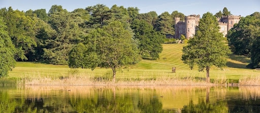
Owned by the Marquess of Cholmondeley, Cholmondeley Estates comprises a mixed portfolio of rural assets in Norfolk and Cheshire. The farmland in Norfolk is managed in a complex rotation of organic combinable crops, vegetables and livestock, whilst in Cheshire it is predominantly dairy country. As well as the in-hand land, there are let farms, forestry, a residential and commercial portfolio and tourism centred round the house and gardens at Houghton Hall, Norfolk and Cholmondeley Castle Gardens in Cheshire. Also in Cheshire is the new BeWILDerwood “Curious Treehouse Adventure” park and both Estates host events ranging from The Houghton Festival to Tough Mudder and Pony Club Championships.

Flexible uses for a diversified rural estate
With a wide range of land uses and activity across the Estate, Cholmondeley use The Land App to map everything from farm business tenancies and grazing licences to rotation plans for organic farming and river catchment management strategies.
“The Land App is very flexible; we use it to delineate everything from a small space such as an office to an agreement that covers two thousand acres, without any difficulty at all.”
Organic farming and environmental management are both important aspects of the Estate’s strategy and underpin its long-term commitment to improving soil health and promoting biodiversity. In addition to mapping existing stewardship agreements, James and the team use The Land App to plan farming rotations that will increase the carbon content of its soils, amongst other things.
The software has also enabled Cholmondeley to work with ecologists as part of its approach to river catchment management as it looks to improve water quality.
“Working with our ecologist, we were able to map the river catchment on The Land App and subsequently decide where best to place dams and structures, as well as identify potential areas for reintroducing lost species.”
Streamlined communication for team efficiency
One of the key benefits of using The Land App has been the streamlined communication between the team, as well as with external parties such as consultants and contractors. The ease of use, streamlined communication and greater efficiency has helped the team to focus more on strategic estate management and generally contributed to a greater level of management expertise.
“It helps us to easily communicate with each other and be more accurate with the various plans, agreements and licences we need to prepare. The Land App in general has also raised our level of management expertise.”

50% productivity increase in digital mapping
James believes The Land App has increased the team’s productivity by at least 50% when it comes to digital mapping. Whilst the tangible results will ultimately be on-the-ground, the software will enable Cholmondeley to progress many of the environmental projects and ecology surveys without the typical delays that are often experienced when trying to share maps and information between various people.
“We’re embarking upon all kinds of surveys across the Estate which would be far more difficult to carry out without the functionality of The Land App.”
Long-term strategic planning for future schemes
Beyond the operational efficiencies gained on regular tasks, The Land App – as a spatial tool – is playing an essential role in helping the Estate to form its long-term strategy. In particular, it allows James and the team to scenario plan and view the Estate in ways that support the formulation of a 25-50 year plan and make informed decisions on how the land should be best managed.
“As a spatial tool, The Land App is essential to helping us formulate our 25-50 year strategy for the Estate that is centred around the UK’s new environmental policy and Net Zero commitments.”
Whether it’s liaising with trustees, considering the ways that farming is changing or planning ahead for new regulation contained in the UK’s Environment and Agriculture Bills, James believes The Land App will be fundamental in this new era of land management.
Modern software designed for land management
Prior to moving to The Land App, Cholmondeley had been using bespoke mapping software for the past 15 years that had gradually become out-of-date.
“It was increasingly difficult to find software that was still compatible with our old system; it had just become outdated, clunky and time-consuming. The Land App is fast and flexible. We use it all the time, right across the Estate.”
A key factor in convincing James and the team to transition to The Land App was the understanding of the rural sector and user requirements that The Land App team demonstrated.
“Unlike a lot of mapping software, The Land App has been designed by people who understand rural estate management and farming, and the various layers and intricacies of the sector.”
