
June’s update introduces a Capital Items 2026 template ahead of the July grant window, Local Nature Recovery Strategy data layers, an updated Predictive Agricultural Land Classification (ALC) map, improved CRoW coverage, updated flood mapping data, and small but meaningful workflow improvements. The following updates are available for all users; there are no standard or professional updates this month.
Capital Items 2026 Template
A Capital Items 2026 template is now available, covering:
- Capital Grants 2026 — applications open July 2026
- Higher Tier Capital Grants — year-round applications
- Capital Grants Plans — year-round
- Protection and Infrastructure Grants — year-round
With £225 million being invested through Capital Grants alone this year, navigating multiple schemes and funding limits can be complex. This template brings everything into one place, supporting confident planning ahead of the July window.
Track spending against funding limits with plan reports.
Map your capital items to relevant feature types and use plan reports to track your spending against the funding limits for each category:
- £35,000 for the boundaries, trees and orchards group.
- £25,000 for each of the water quality, air quality, and natural flood management groups.
Copy from CSHT 2025
If you already have a Countryside Stewardship Higher Tier 2025 plan, you can copy it directly into the Capital Items 2026 template, or vice versa, while maintaining feature codes.
Updated items
The template also includes TE19 (Tree guard: narrow weld mesh), and the updated names for TE7 (Tree guard: large post and rail) and TE8 (Tree guard (small post and rail and wide weld mesh). We’ve also applied these changes to the CSHT 2025 template for consistency.
Data Layers
Local Nature Recovery Strategies (LNRS)
Local Nature Recovery Strategies (LNRS) are now available as a dedicated layer category in Land App. A master layer shows the boundaries and status of each LNRS across England. Three detailed layers are also available for Greater Manchester and Norfolk & Suffolk:
- Areas of Particular Importance for Biodiversity (APIB)
- Areas that Could Become of Particular Importance for Biodiversity (ACB)
- Potential Measures
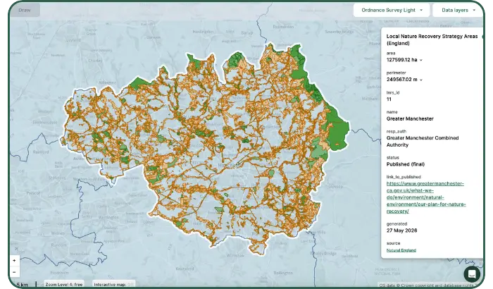
For BNG, habitat restoration, agri-environment scheme planning, and nature recovery projects, LNRS data is increasingly central for demonstrating local relevance and identifying priority areas. Having it directly in Land App makes it easier to overlay with farm boundaries, habitat data, and existing plans.
Natural England is due to publish a consolidated national layer, which we’ll add as soon as it’s available. In the meantime, if there’s a particular LNRS you’d like to see added, get in touch at support@thelandapp.com.
Predictive Agricultural Land Classification
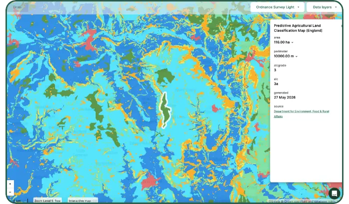
Defra’s Predictive Agricultural Land Classification (ALC) map is now available, replacing the older Provisional ALC map. It provides more consistent, spatially comprehensive coverage of land quality across England, drawing on the best available soil data from Cranfield University’s LandIS platform and 30-year climate averages.
The layer grades land from Grade 1 (excellent) to Grade 5 (very poor), with Grade 3 subdivided into 3a and 3b to identify Best and Most Versatile (BMV) land.
Updated CRoW data layers
Our CRoW data layers now align with the official naming and segregation of the source data. Previously, the CRoW Common Land layer combined the England Access Layer (which itself covers Dedicated Land, Conclusive Open Country, and Conclusive Registered Common Land) with Open Access Registered Common Land for Wales. These are distinct datasets that weren’t well represented under a single label.
Most importantly, the data hasn’t changed; the organisation and naming now reflect the official structure more accurately.
England — new and updated layers:
- CRoW Act 2000 – Access Layer (England) — previously included within the CRoW Common Land layer, now clearly separated.
- CRoW Act 2000 – Section 4 Conclusive Registered Common Land (England) — updated name
- CRoW Act 2000 Section 4 Conclusive Open Country — new
- CRoW Act 2000 Section 15 Land — new
- CRoW Act 2000 Section 16 Dedicated Land — new
England — new and updated layers:
- Open Access Registered Common Land (Wales) — previously included within the CRoW Common Land layer, now clearly separated
- CRoW Open Country (Wales) — new
- Open Access Other Dedicated Land (Wales) — new
- Open Access Other Statutory Access Land (Wales) — new
- Open Access Dedicated Forests (Wales) — new
Upcoming change to Floodzone 2 and 3:
We will soon be removing Floodzone 2 and Floodzone 3 data layers, as the Flood Map for Planning has superseded them. Users of these layers are encouraged to switch to the Flood Map for Planning, which provides more up-to-date and comprehensive flood risk information.
UX Improvements
Three small but useful workflow improvements this month that add up across longer mapping sessions:
Confirm modals using keyboard
- When filling out a single text input modal (e.g., for plan or folder names), press Enter to confirm changes instead of clicking OK.
Shift-click to deselect features
- When selecting multiple features, you can now use shift-click to deselect individual features, either on the map or from the feature list in the left-hand panel.
Save attribute edits more quickly
- When editing a text attribute, pressing Enter now confirms your changes instead of requiring a click on the tick icon. For multi-line text, press Ctrl+Enter (Windows) or Cmd+Enter (Mac) to insert a new line.
Missed May’s Updates?
Last month, we added the England Peat Map data layer, raised the per-user team tag limit to 100, introduced GB-wide print frames, and made several interface improvements. Read the full May Product Update to see what’s new.
Want to see what’s new? Log in to your Land App account now to explore the latest updates. If you have questions, just email us at support@thelandapp.com.
