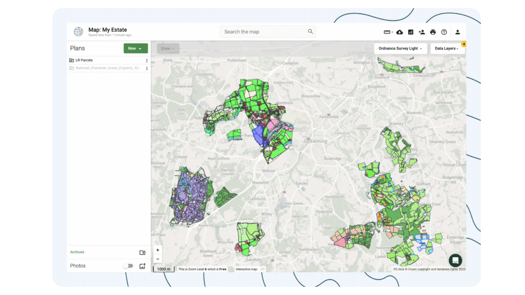
Landowners & Estates

Minimise risks, assess funding opportunities and manage assets

Trusted by

A powerful digital mapping software used across the UK to assist with estate-wide planning, strategy and funding a resilient future vision

Land App is trusted by landowners and estates all over the country. From portfolio management to agri-environment scheme applications to cutting-edge mapping for natural capital projects, Land App is the go-to tool for financial and ecological resilience for estates.

What are the benefits?

Get a clear view of the impact that decisions will have

Access the latest datasets (such as Ordnance Survey Master Map, Rural Payments Agency, UKHAB), rapidly baseline your estate with pinpoint accuracy, and use our comprehensive library of geospatial data layers and collaboration features to help understand and plan the best possible land use for your estate.

Efficient and collaborative, Land App’s cloud-based technology allows you to choose who you share your data with, be it tenants, funders or advisors.

Prepare for replacement natural capital funding

Bring clarity and efficiency to your operations

Manage multiple holdings with ease

Assess options using a single authoritative source

Collaborate with tenants in a cohesive way

Baseline and plan sustainable projects across your estate

Be it natural capital trading, rewilding or government funding applications, Land App helps you consolidate and understand the present state of your land use, and confidently plan for the future. Partnering with leading organisations and government bodies, we equip our users with the digital tools they need to navigate the agricultural transition and unlock a sustainable future. 


What does Land App offer?

Collaborate with your whole estate team across a variety of maps, design projects and government scheme applications using our templates and workflows to easily consolidate your portfolio and access new income.

pricing

Choose the right plan for you

Free

Simple mapping toolkit to quickly digitise plans and key information
Free Forever
  • Intuitive digital mapping tools
  • Up to 4 maps on your dashboard
  • Invite view-only collaborators
  • Unlimited plans
  • Unlimited photos
  • See sponsored opportunities for funding
  • Access government data layers
  • Automated workflows from key partners
  • Free training webinars and online help guidance
  • Pay as you go for prints and data purchases

Standard

Collaborative mapping system to engage your team and reduce costs
£10 Per person, billed monthly/annually
  • Everything in Free, plus:
  • Unlimited maps
  • Land App Mobile
  • Access commercial data layers
  • Invite editor collaborators
  • Manage your teams and users
  • 20% discount on prints and data purchases
  • Ordnance Survey API key
  • Live customer support
  • Consolidated billing for your team
  • Pay monthly in arrears or annually upfront
Popular

Professional

Insightful data analysis to guide strategy and unlock opportunities
£30 Per person, billed monthly/annually
  • Everything in Standard, plus:
  • Land App Professional Dashboard (BNG)
  • Bespoke data layers for your team
  • Land App API key [available only when all users are in professional]
  • Bespoke training for your team
  • Dedicated account manager
  • Pay with BACS transfer

Have additional questions?

Send us an email to support@thelandapp.com

what our users say