Land App is partnering with UKHab Ltd, the creators of the UK Habitat classification, to help ensure the UK Habitat classification is accessible to a broad range of stakeholders and becomes the default classification system for use in the UK. The partnership will look to focus on:
Facilitating the delivery of better environmental outcomes
Providing the data and digital infrastructure to support real outcomes on the ground
Increasing capacity, consistency and competence in habitat surveys
Sector consistency will be essential as new schemes and natural capital markets develop
Support the update of the classification through updates from Land App users
As the classification develops, we welcome feedback from users to ensure it is the best it can be
Support users of UKHab and deliver high-quality training
The partnership is committed to comprehensive training for habitat surveys and assessments
Land App and UKHab: Key Features
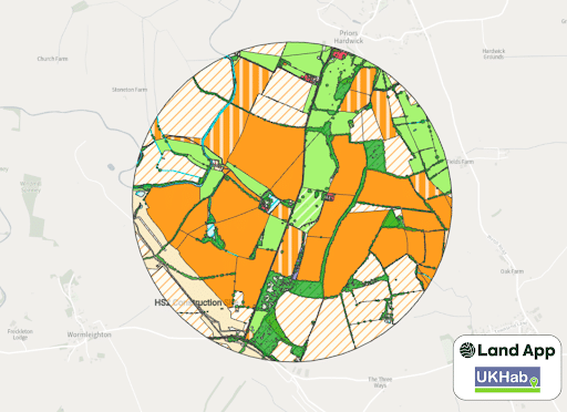
The UKHab Best Guess Baseline
After the popular release in early 2023, Land App and UKHab have made some iterative improvement to the UKHab Best Guess Baseline. This data model runs a live data query on your area of interest, returning a “Best Guess” of the habitats and features that make up your area of interest.
The data layers interrogated include layers from Ordnance Survey’s MasterMap Topography, government agencies (such as Natural England’s Priority Habitat Inventory, and Forestry Commission’s National Forest Inventory), and Earth Observation Data.
Our latest improvements now include:
Serve Vegetation Object Model for England for all vegetation types taller that 2.5 metres
Temporal Detection of grassland determines differences between temporary and permanent grassland
Arable fields are assessed for the presence or absence of winter cover over months of November to January.
Land classification capabilities in Moorland areas improved, namely ‘Upland heathland’ (h1b). Misclassification of grassland (g) and Temporary grass and clover leas (c1b) in Moorland areas is now reduced.
Woodland classifications improved, now providing level 4 classifications for broadleaved and coniferous woodland and forest.
More features to come!
If you want to learn more about the UKHab Best Guess Baseline, including getting a quote, please see here:
The second official version of the UKHabitat classification was released in late summer 2023, and now all the official codes can be found in the “Baseline Habitat Assessment” and “Land Management Plan” templates. The release sees more than 10 new primary habitats, including:
g2c (Other calcareous grasslands),
h3j (Juniper scrub),
r1g (Other standing water)
c1c9 (Arable fields – cultivated for annual flora),