
Introduction:
One of the central – and most important – themes of the agricultural transition is Landscape Recovery, the idea that we must coordinate projects at the landscape or ecosystem level to achieve meaningful and lasting ecological resilience. The Wendling Beck Environment Project exemplifies this approach, coordinating multiple land holdings to achieve Biodiversity Net Gain and the restoration of a river catchment. To appraise and plan land use change at this scale is complex, however, and requires innovative approaches in data and mapping to underpin and inform decision making. This case study highlights the work that Land App has undertaken in partnership with Wendling Beck, alongside key partners such as eCountability and Viridian Logic. Land App is participating as the official mapping partner, providing tools and digital consultancy services for habitat baseline mapping, collaborative land management and spatial data management. The partnership demonstrates the benefit of using geospatial data modelling for reducing cost, improving the speed of future scenario mapping, and delivering accurate ecological and financial models for natural capital accounting.
About the Wendling Beck Environment Project
Wendling Beck represents a groundbreaking approach to conservation and land management in England. It seeks to leverage new nature markets to finance long-term project delivery through the sale of ecosystem services (ESS). This will include trading environmental ‘credits’ for biodiversity net gain, nutrient neutrality and natural flood management, whilst retaining some regenerative farming elements. Spanning four farms covering an area of 2000 acres, the project estimates it will deliver around 2,500-3000 biodiversity net gain (BNG) units, sequester 250,000+ tonnes of carbon and restore approximately 5,000 metres of river corridors.
Whilst transitioning land in order to create and restore semi-natural habitats, it also seeks to maintain food production through regenerative practices and grass-fed livestock, which will also be used to manage new high distinctiveness habitats such as lowland meadow. Ultimately, Wendling Beck hopes to “create a model which is both financially and environmentally resilient and encourages others to follow a similar journey, creating connectivity within landscapes and delivering these benefits at a scale that really makes a difference”. To learn more about Wendling Beck directly, you can visit their website here.
Section 1: Creating a Baseline
Comparing manual and digital biodiversity surveys.
At the outset, any project aiming to invest in its natural capital, or trade ecosystem services, must first produce a “baseline” assessment – an accurate map of the existing ecological layout and condition. Once finished, future land use changes or “scenarios” can be designed, meaning their impact and uplift can be measured against the existing baseline.
At Wendling Beck, a comparative baselining approach was taken. Initially, a UK Habitat Classification (UKHab) biodiversity survey was undertaken by the expert ecologists at eCountability. Survey data was collected manually, before a digital scenario map was developed showing different options for land-use. In turn, a second survey was undertaken using Land App, a process using our UKHabitat “Best-Guess Baseline”, which cross-compares geospatial and habitat datasets to provide an accurate approximation of land use (where habitats are given a ‘code’ in the UKHab format). This was then compared against the manual, ground-truthed survey data. Ultimately, the purpose was to compare the outputs of both surveys, to assess the viability of using the Best Guess Baseline to support and streamline the manual survey, which can sometimes produce problematic inaccuracies in the data .
As we illustrate here, manually drawing features onto a map can lead not only to misrepresenting land-use, but overlapping sections can produce “double-counting” of an area, meaning the ecosystem services being provided by a project are not accurately displayed. The Best Guess Baseline, by contrast, is underpinned by the authoritative Ordnance Survey MasterMap Topography data layer, meaning that all the features on the data are “clean”; without overlap.
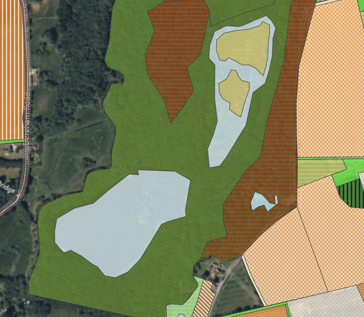
Figure 1. Layer 1 – Ecological surveyed file by eCountability, with detailed UKHab assessment and condition scores, focusing on a woodland block around a lake. This process produces high quality ecological insight, but has limitations in geospatial accuracy.
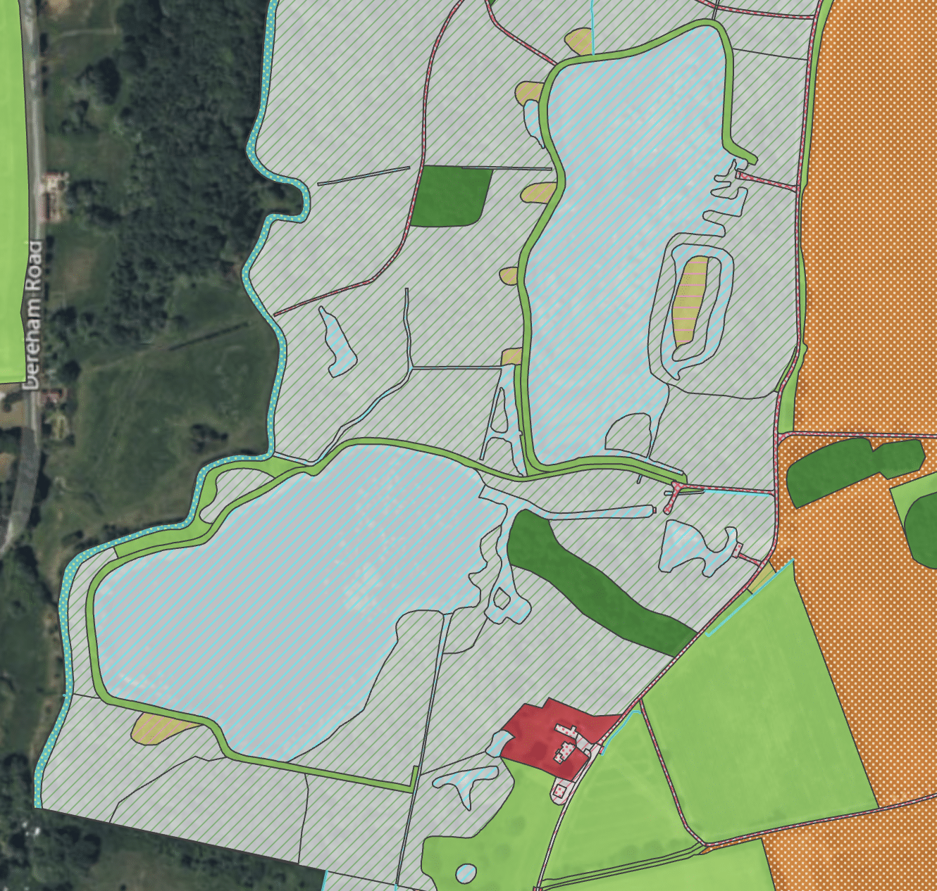
Figure 2. Layer 2 – UK Habitat Best Guess Baseline (underpinned by Ordnance Survey MasterMap) does not reach the same degree of ecological details (primary habitat code or condition score), but produces finer detail in the geometry of the data, especially for small, intricate features.
Figure 1 shows the hand-drawn map of an area of water and woodland from Wendling Beck. Figure 2 is the map produced by Land App. When placed side by side, it is clear that the detail provided by the Best Guess Baseline (underpinned by Ordnance Survey MasterMap Topography) provides finer granularity, especially with respect to urban features (tracks and buildings) and water (rivers, lakes and ponds). Whilst this does not give a fully accurate survey – ecologists are far better placed to determine habitat condition for example – it does highlight how pre-existing data can support and refine work carried out on-the-ground.
Double counting:
Manual mapping clearly creates the risk of double counting, or misrepresenting, habitats.. Figure 3 demonstrates the risk of overlapping habitat polygons, which in turn would skew the data output to suggest there is more of each habitat present than there actually is. Conversely, Figure 4 represents the inverse; where areas of land have been left without a designated habitat, leaving a gap in the data and therefore presenting an inaccurate output. Hand drawing alone risks producing an inaccurate digital twin of the land area, with the corresponding ecosystem services misconstrued. In turn, this potentially undermines the integrity of natural capital trades or investments.

Figure 3. Manual drawing of features on some overlapping features

Figure 4. Manual drawing also created areas without a habitat code (especially buffers)
Summary of Findings and Future Recommendations:
Having standardised, accurate data is imperative for any ecosystem services transaction where credits are sold or purchased. To ensure that the service being “delivered” can be accurately understood, a reliable digital baseline must be created. Ultimately, our comparison between the two methods demonstrates that they should be used in conjunction. This approach is beneficial not only for the quality of the final dataset – and therefore natural capital accounting – but can represent reduced costs to the project in the substantial amount of time saved. The study demonstrated that having a Land App “UKHabitat Best Guess Baseline” as a starting point (before any ecological surveying work) is a benefit to the ecologist, the private or government investors, and the project managers themselves. Importantly, though, this represents a “head start” to surveying and scenario appraisal, not a replacement for it. Ground-truthing by a trained ecologist is essential if an accurate BNG assessment is being completed (especially for gathering detailed habitat notes and condition scores).
Section 2: Land Management Scenario Planning
Once the baseline has been completed, it acts as an authoritative dataset for the project area’s existing natural capital. In turn, this allows for the project participants and partners to work together collaboratively, developing a land management plan to create environmental uplift and access funding. In this instance, a two-stage process was carried out. Working with the land managers and partners, eCountability helped draft a “scenario” (a proposed land management plan) for the project; detailing where would be best for woodland planting, grassland restoration and the creation of wetlands.
Independently to this, Land App also ran a digital scenario, using algorithms running on environmental “spatial rules” to show areas that were eligible and suitable for specific management interventions. It was found that there was a strong correlation between the output of Land App’s suggestions and those proposed by the surveyors and advisors who contributed to the initial, ground-truthed survey.
At a high level, Land App’s role here was twofold. Initially, its value lies in the easy-to-use mapping tool to plan options for the future, providing editable data in a format that is already compatible with BNG and other environmental market schemes. It is imperative a group can understand where uplift can take place and how much land a farmer is willing to take out of production (and thus the potential income foregone). Secondly, the use of automated suggestions (produced with research partners) aims to ensure that all habitat and ecological datasets are cross-referenced to reduce the human margin of error (such as proposing woodland creation on ineligible soil type).
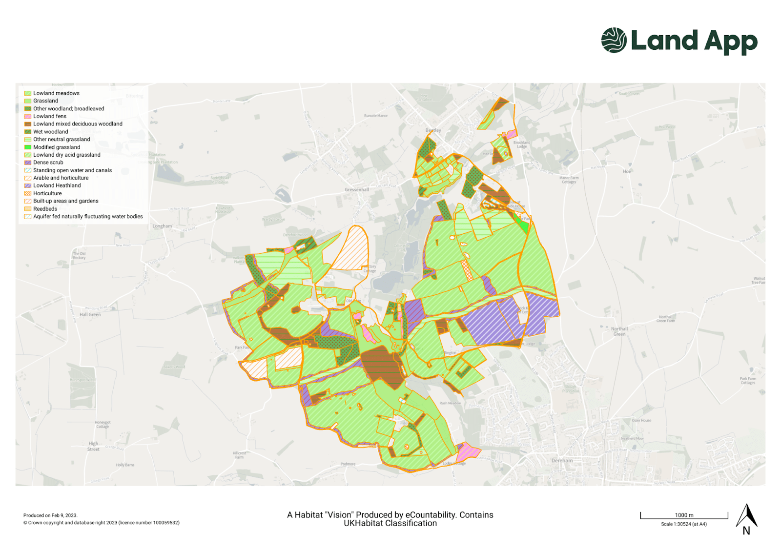
Figure 5. A version of a habitat “vision” created by Wendling Beck land owners with the help of eCountability, 2021.
Land Management Auto-Suggestions
Land App set out to identify key areas that were initially missed or had ecological potential that had not been fully realised. This consisted of three core “workflows” or planning options; Woodland Creation, Wetland Creation and a Waterflow Accumulation Model.
- The England Woodland Creation Offer (EWCO): Working in partnership with the Forestry Commission, Land App have developed an algorithm (that is due to be released later in 2023), or “workflow”, which analyses a given area of land, and geo-spatially indicates areas of eligibility for woodland creation (especially stackable payments). This allows all users who are considering applying for EWCO to drastically streamline the application process, saving time and ensuring ecological accuracy when drafting a land management plan. Moreover, this is linked to both the initial and maintenance payments offered by the scheme, so appraising how much land could be feasibly used for woodland creation is given essential financial context for decision-making.
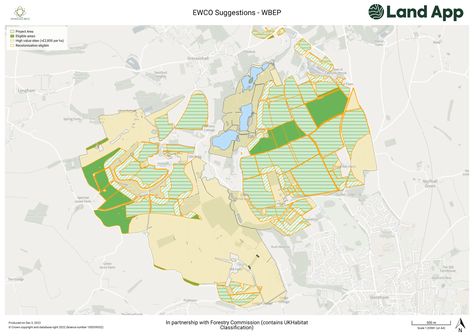
Figure 6. The output from the Land App’s England Woodland Creation Offer for the Wendling Beck project area. Shows all sites that are eligible for EWCO payments, where sites are high value (worth over £2,800 per/ha in supplementary payments) as well as sites that are within 75m of existing woodland, and thus eligible for establishing the woodland through natural colonisation (avoiding the capital investment needed for whips and guards).
Avoiding Human Error:
Here the tool was essential for highlighting human error. For example, the ground-truthed scenario suggested creating around 4 hectares of woodland which, when cross-referenced against the EWCO data suggestions, was found to be ineligible for funding due to being on peat. This would have resulted in the application being rejected by the Forestry Commission. As Figure 7 demonstrates, the land can be cross-referenced against essential data sets (such as Natural England’s peat map) and such mistakes can be ironed out in the early stages of planning.
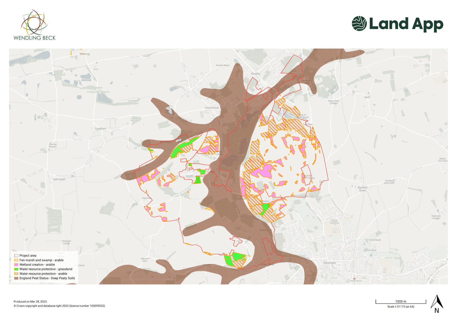
Figure 7. Land App map showing the England Peat Map data layer with UKCEH E-Planner datasets highlighting target areas, overlaying the Wendling Beck project.. (For full acknowledgements for the E-Planner data, see here).
- Wetland Creation: A second phase was the Wetland Creation workflow. This analysed the project area and automatically served suggestions as to which areas of land were suitable for wetland creation. For the Wendling Beck project area, the Wetland Creation Algorithm detected 12.64 ha of potential wetland to be created. Crucially, wetland creation illustrated the possibility of a blended, or “stacked” financing approach. Not only was it potentially suitable for the Countryside Stewardship Scheme (option GS11: Creation of wet grassland for breeding waders), but there are also funding opportunities from private investment for contributing to nutrient neutrality (phosphate and/or nitrate offsetting).
- Waterflow Accumulation Model: A key element of the land management planning was appraising where was best to place water management interventions. This water flow accumulation model operates using the LIDAR Composite DTM (Digital Terrain Model) as shown in figure 8. Here, Land App detected key fields where water is naturally pooling or flowing. These sites could either be ideal for pond/scrape creation, or where surface roughness could be increased by allowing scrub encroachment / tussocky grasses to form.
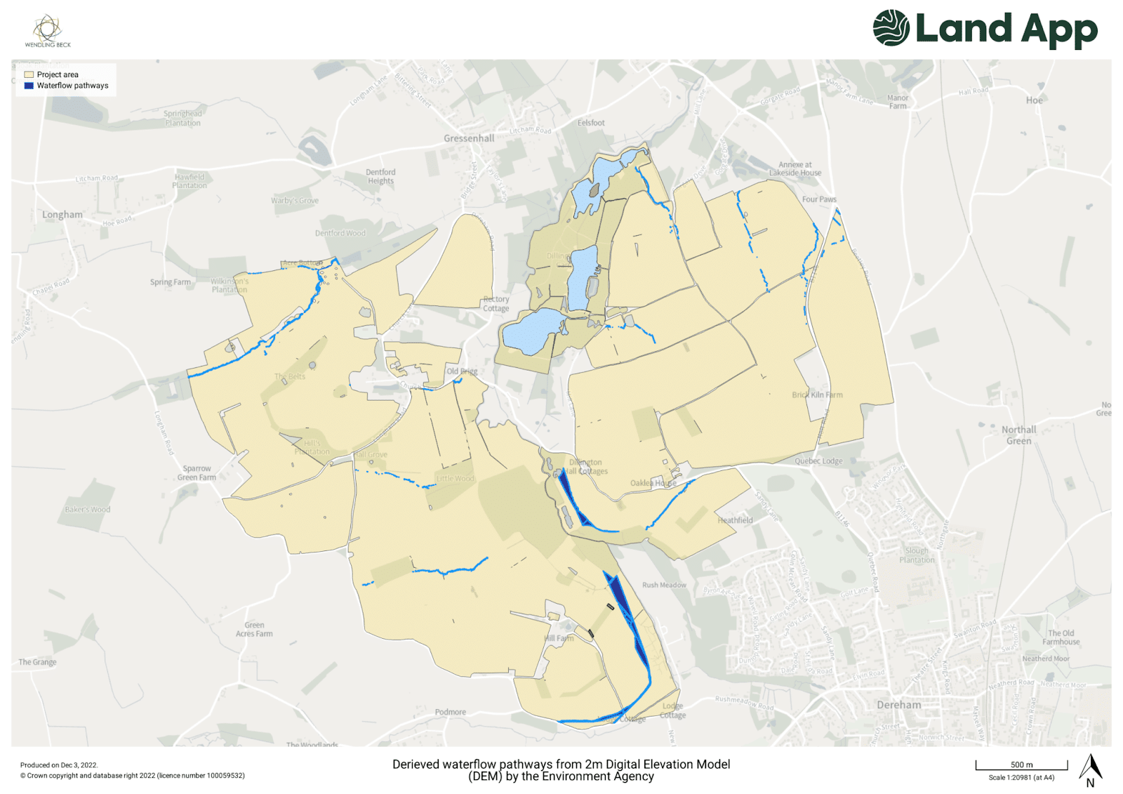
Figure 8. Waterflow accumulation models using the LIDAR Composite DTM (Digital Terrain Model), identifying where water tends to flow during rainfall
Viridian Logic: Natural Flood Management and Ecosystem Services
A key delivery partner of Wendling Beck was Viridian Logic, a nature-based solutions organisation providing “natural flood management & ecosystem service solutions for valuation, planning, and decision support”. Viridian provided up to 15 data layers with their calculations and recommendations as to where the landscape would most benefit from water-systems management.
The objective at this stage was to combine partner-led professional research with machine learning modelling, to identify areas of alignment. As Figure 9 demonstrates, there were instances where the recommendations produced by Viridian Logic and Land App had compelling overlap. Consequently, it was recommended that this was a location where water flow management was a highly advantageous option for the land manager to undertake.
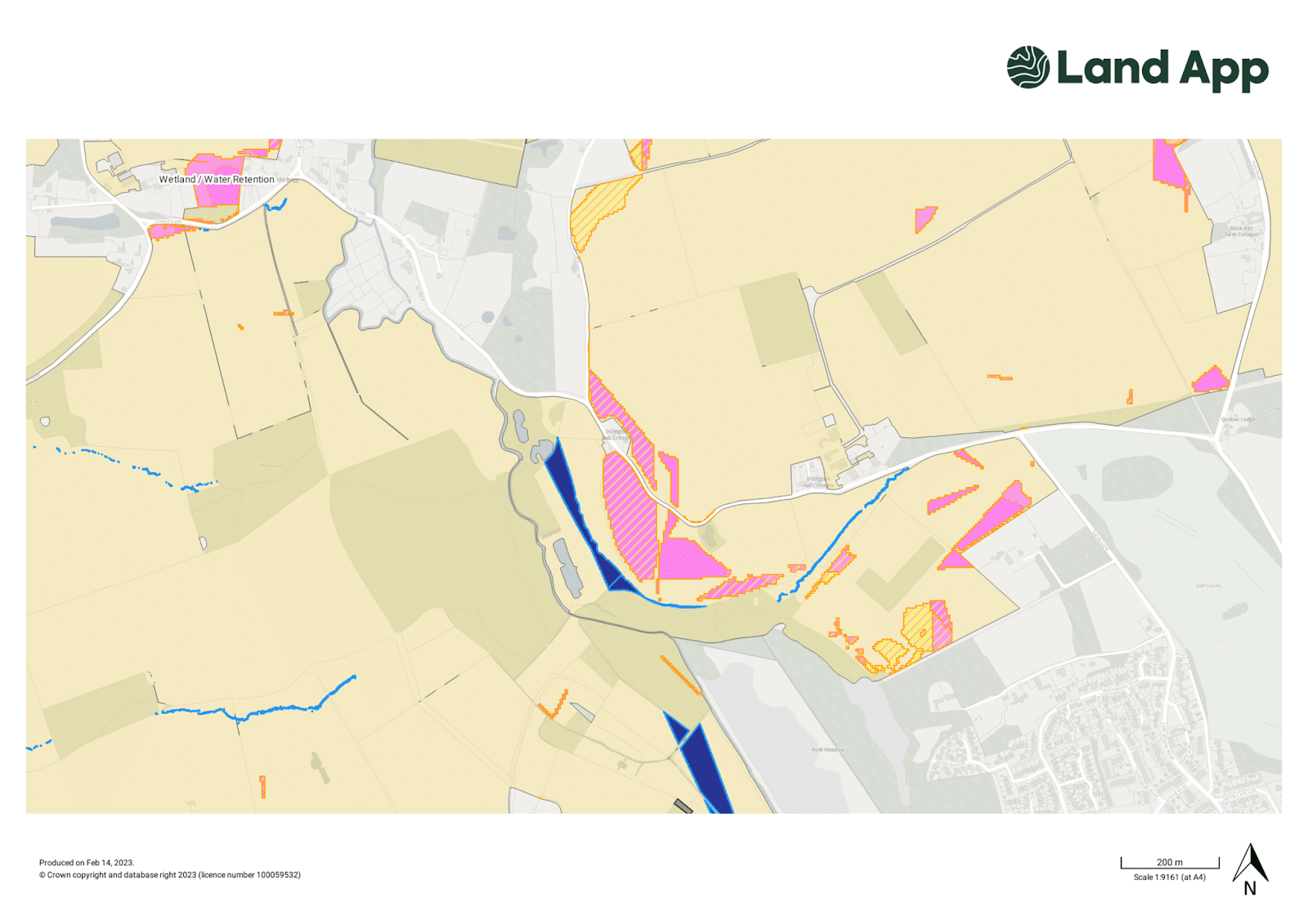
Figure 9. A close-up of Viridian Logic’s overall recommendations for management (pink data layer) compared against the Land App Waterflow accumulation models (blue data layer)
Step 3: Designing Scenarios
After consulting the recommendations from both Land App’s and our partner’s datasets, interventions could be easily drawn up on the Land App (using our mapping tools) and linked to potential funding opportunities. For example, taking the most compelling area of overlap for the water datasets demonstrated an ideal location for installing ponds for water management. Cross-referencing this against the data layer for “Great Crested Newts – Strategic Opportunity Areas (England)” meant we could identify areas where the addition of new ponds would benefit Great Crested Newt populations defined as strategic opportunity areas (SOAs). The resulting pond creation plans could be assigned its UKHab code and as a result, the uplift in biodiversity could also be calculated..
In total, Using the data from above, Land App created an example future vision of the Wendling Beck project area, and can quantify the impact through connectivity and biodiversity units. The interventions chosen were:
- Pond Creation – four ponds – 0.54 ha
- Wetland creation (all suggested sites) – 12.6 hectares
- Woodland creation – recolonisation eligible sites only – 57.46 ha
Collaborating With Partners for Landscape Recovery
The importance of collaboration, and having a digital resource which enables this, is paramount for a successful landscape recovery project. As the input from partners demonstrates, importing multiple sources of data and recommendations for land management into a centralised and standardised map enables multiple “scenarios” to be appraised (both from an ecological standpoint and for financial viability). It is this comparison of different options that is so vital for success. Empowering the land managers on the ground to assess where income may be foregone – that is, how much of an area they believe is viable to take out of production – is critical. We believe that Land App’s collaborative features brought the following key benefits throughout the project that are directly relevant to anyone seeking to replicate the landscape recovery model.
- Use Land App to confirm and amend the baseline data, using the data report feature to cross-reference with other data sources where needed.
- Import suggestions generated by partners: eCountability drew up “scenarios”, whilst Viridian Logic had 15 various data layers. The project managers then decided which features they wanted to introduce, creating a scenario on Land App.
- To identify potential human error. As shown in the EWCO section, an initial scenario suggested roughly 4 hectares to be created on peatland. However, the EWCO template flagged the area as unsuitable from the offset, and as a result prevented an unsuccessful application process due to constraints on planting on peatland.
Summary:
Overall, the Land Management Planning Stage demonstrated a successful collaborative model in which having Land App as the mapping tool – not only to produce a “digital twin” of the existing state of nature but also for future scenario planning – proved invaluable. As the previous sections have highlighted, any nature recovery project must be underpinned by authoritative and reliable data. Using automated land management suggestions in partnership with external parties’ data and suggestions is the ideal model. We do not expect, nor recommend, that these will supplant the role of accredited professionals working on these projects to ground truth and finalise decisions. What the study has shown, however, is a real opportunity to reduce costs and help counter human error in both the baselining and the planning phases.
Not only was there a strong correlation between the Land App survey and recommendations produced by advisors, but the collaborative and easy-to-use mapping features meant multiple scenarios could be drawn up and appraised – before an option could be chosen that made the most ecological and financial sense for the project. Critically, given the standardisation of the data into the UKHab format, all data produced was ready for assessing Biodiversity Net Gain units, Nitrate reduction under nutrient neutrality, funding value under England Woodland Creation Scheme (EWCO) and other public funding schemes. As the next phase of the project will demonstrate, this is critical for landscape recovery projects to maximise the opportunities of a blended finance model, and thus ensure sufficient levels of investment into nature recovery.
With thanks to project partners:


“The Land App is a very impressive tool: the simple, intuitive user experience hides the hugely complex and detailed processes that power it. It is a great way of working with many rich and adaptable datasets such as our ranking and prioritisation of nature-based solutions, as it simplifies data integration to extract valuable insights” – Angus Middleton, Viridian Logic
“Wendling Beck chose to work with Land App as it is so easy to get land boundaries into the platform and we could do it ourselves without specialist help. The Land App platform works particularly well in large collaborative projects with multiple landowners – it gives us the ability to play around with different land-use scenarios. Once we had the basics mapped, Land App were really supportive in layering in additional data sets like habitat connectivity, water pathways and historical map data, which are key pieces of information for project decision making and understanding how to get the right habitat, or nature-based solution, in the right place”. – Glenn Anderson, Wendling Beck Environment Project
Data Acknowledgements:
- Contains Ordnance Survey data (OS MasterMap Topography and OS Raster 1:25,000) – © Crown copyright and database right 2023 (licence number 100059532)
- E-Planner Data has been made available with thanks to UKCEH, in partnership with Sainsburys (learn more here – https://thelandapp.com/2023/03/01/sustainable_supply_chain_sainsburys/ ) – for full data acknowledgements, see here.
- Contains © UKHab LTD, under license. No onward license implied or provided. All rights reserved. For more infomation please visit http://ukhab.org/commercial-eula/
- Thanks to eCountability and Viridian for their permission to share the data produced.
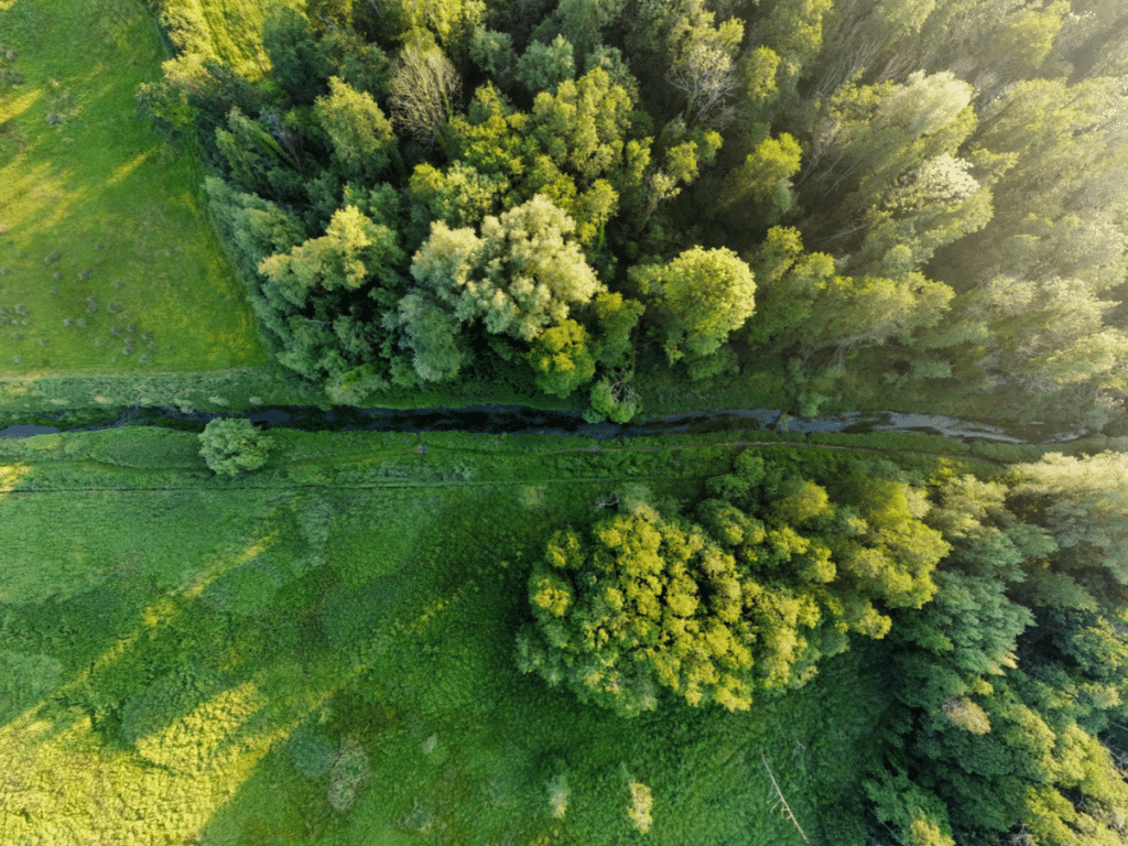
*Credit for the header image: Alex Sidney “Wendling Beck @ Rush Meadow” from the WBEP website
