
As a result of post-Brexit funding mechanisms changing, many land managers across the country are looking either to increase their participation, or to begin including Environmental Land Management Schemes (ELMs) as a funding option. Applications will correspondingly increase, inevitably placing pressure on the bureaucracy and the traditionally paper-dominated system that oversees them. Given the urgent need for greater uptake in nature-friendly schemes, it is important that there are no blockers in quickly and easily accessing them. Moreover, as government publications and policy increasingly acknowledge the need to regulate competing claims to land use – from nature, clean water, farming, green energy and housing – ensuring applications are in line with these demands is imperative. In short, the national transition to nature friendly farming risks being slowed by complexity, inertia and insufficient bureaucracy to support it.
So what’s the problem?
Currently, the processes that underpin all of these applications are inefficient: Land managers know the painstaking process of drawing up and submitting an RLE1 form to register a boundary change in paper form. Countryside Stewardship is no different: it can be a time consuming and expensive process with input from multiple stakeholders all before knowing whether it is a financially viable option for the farm. As applications inevitably increase with people seeking to diversify their funding options, these issues will be compounded.
Moreover, there is an overwhelming amount of paper used in submissions. If digital submissions directly to the RPA could be enabled it would create a seamless system, both simplified and more efficient. The Guardian last week highlighted that “Defra and its organisations handle about 14m paper transactions a year”, which has led MPs to comment that “the situation “cannot continue” as officials are having to use paper forms rather than digital systems”.
It is clear that the transition to digital mapping comes with the expectation of digital submission to accompany them, something which Land App would be well placed to facilitate. 24,530 Countryside Stewardship Plans have been created on the software since 1st of January 2020 (and 1828 SFI plans since February 2022), with many more expected in the coming years. Indeed, the growing popularity of Countryside Stewardship in recent years is clear to see. Defra recently published figures highlighting that in January 2023, there were around 32,000 CS agreements, a 94% increase from 2020. We anticipate that, given Land App’s position as a digital solution to many of these issues, this demand will only increase from our 17,000 registered land managers, farmers and advisors.
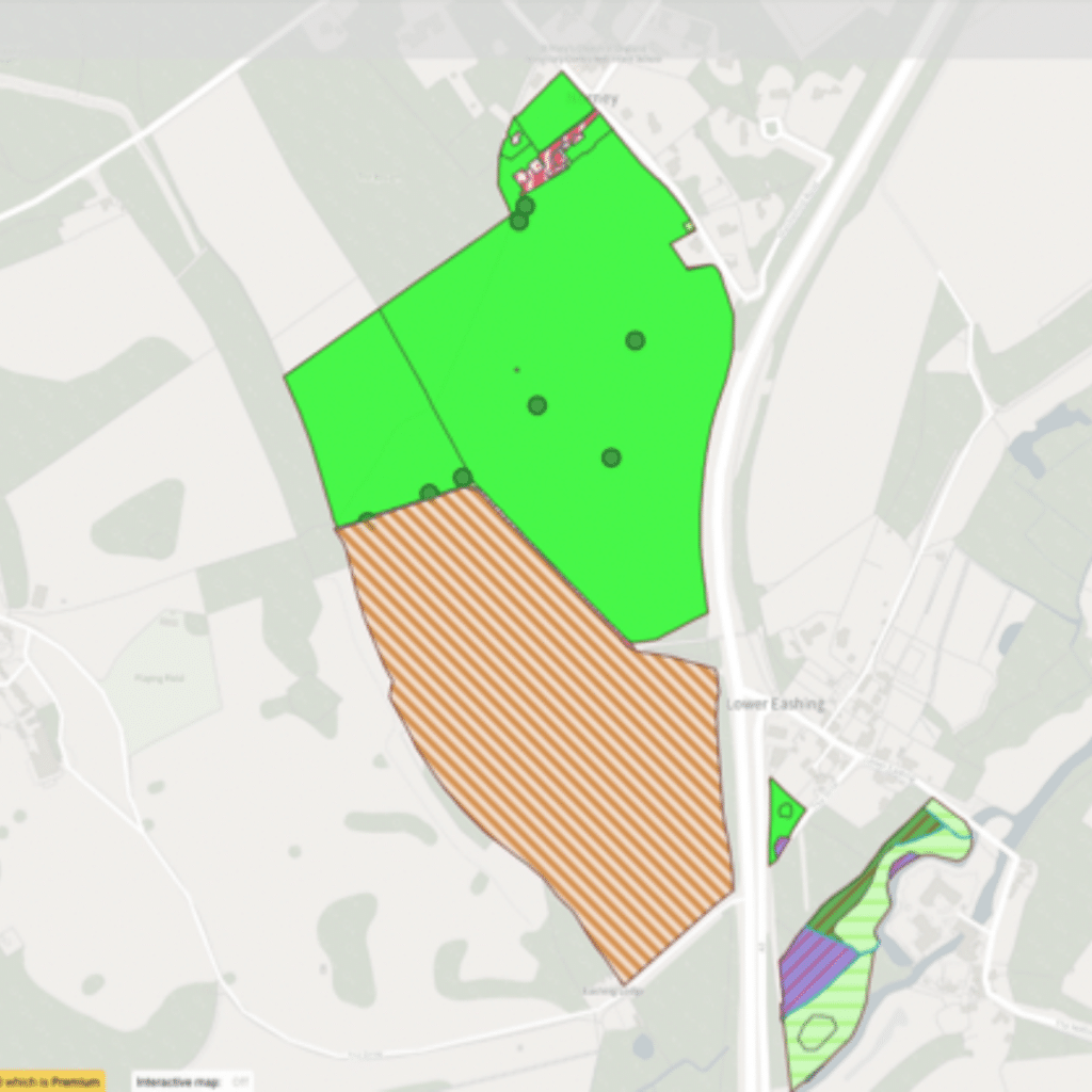
An example Land App baseline map of Norney Farm linked to option codes for funding schemes. Surrey, UK
Where does Land App fit in?
As Stewardship and the other ELMs schemes expand (as well as private mechanisms such as Biodiversity Net Gain), ensuring that there is an adequate system to support these applications is essential. This has been the core of Land App’s work over the last three years. Founded on a family farm in Surrey, we believe that land managers must be provided with the most reliable tools possible to reduce costs and time, whilst significantly improving both the accuracy of the plans and their ecological resilience. Geospatial data layers over a farm or estate boundary demonstrate features in that area of land, such as SSSIs, Flood Zones, and Priority Habitat areas, to quickly assess the viability of certain funding options. Once a plan is drawn up, a table view can be generated instantly, linked to payment rates. A fully valued, highly accurate application can thus be mapped in a manner of minutes. Not only has it been exposed to landscape requirements in the data layers, but collaborative mapping features mean a farming advisor can edit and advise from anywhere.
In the words of Rob Browne, Managing Partner of RB Rural LLP and experienced agricultural advisor; “The Land App is not just a mapping program, it is so much more. If we can produce RPA compliant FER and Option plans already, why can’t we link the data drawn from these very plans into a RPA compliant application format to save duplicating time and effort from farmers and agents? Land App is the answer to all of our frustrations, and I commend that this is considered seriously by the RPA – there are major opportunities to dramatically increase farmer engagement with new schemes.” – Rob Browne MRICS FAAV MBIAC, Managing Partner, RB Rural LLP
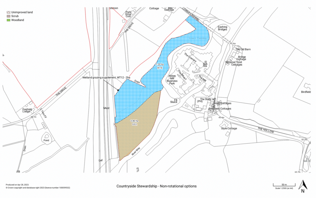
- An example Land App map for non-rotational Countryside Stewardship options
The case for digital submissions is increasingly clear. James Rebanks, a farmer widely known for his engagement with nature in farming, recently commented on Twitter on the risks such lack of infrastructure might pose: “At a time when we need to get more farmers than ever to deliver way more nature for the public good…the door is closed in their faces” – James Rebanks, Twitter, April 13th, 2023.
Digital submissions to government departments would drastically save paper, time and cost for farmers at a significant scale.
Tim Hopkin, Founder of Land App and Surrey-based Farmer: “The paperwork at the moment is time-consuming and expensive for the whole system. It leaves a potential for error and still doesn’t enable farmers to design the right features in the right place to deliver maximum public benefit from the taxpayer investment. We need 100% of farmers across the country to be able to access public money to deliver nature restoration quickly, easily and cost-effectively if we are going to hit our national targets for biodiversity, nature and climate. We must ensure project delivery is easy to administer and monitor for everyone, all of which we have built Land App to help with.”
There are two agricultural transitions at play; one of funding and policy, the other from analogue to digital. We are working around the clock to ensure that Land App meets the demands of the latter, to ensure that the former is supported as best as possible.
