

The UK Habitat Best Guess Baseline is an innovative digital mapping tool that provides users with near-instant access to highly granular habitat information. In this blog, we’ll explore what the Best Guess Baseline is, why it’s useful, how it’s created, and its value to various stakeholders in the land management sector.
What is the Best Guess Baseline?
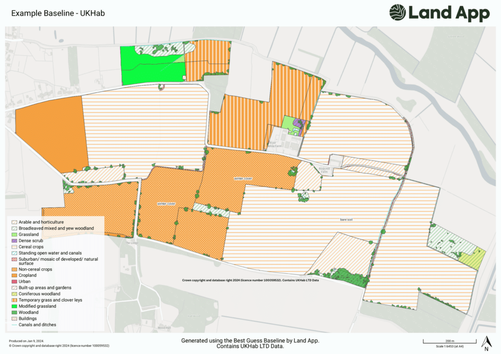
The Best Guess Baseline is a sophisticated, automated system designed to deliver a single data layer that predicts the habitats present in a specified area of Great Britain. It combines insights from multiple third-party datasets, to generate a level 3 UKHab code for each distinct area, providing users with an immediate understanding of existing habitats. This data can include information on woodland, grassland, urban, and cropland features, enabling landowners and managers to make informed decisions regarding land use and conservation efforts.

Why is the Best Guess Baseline Useful?
1. Precision and Accuracy
One of the key benefits of the Best Guess Baseline is its ability to provide high precision and accuracy in habitat delineation. Digital mapping allows for precise spatial representation of habitat boundaries and features, minimising errors commonly associated with manual mapping techniques.
2. Efficiency and Time Savings
Traditional habitat assessments can be time-consuming and costly. The Best Guess Baseline streamlines the pre-survey stage, data collection and analysis, significantly increasing efficiency. With access to various data layers—including satellite imagery, Sites of Special Scientific Interest (SSSIs), and Priority Habitat Inventories—users can gain a ‘best guess’ of what’s on the ground, before conducting field surveys. This proactive approach saves valuable time and resources, allowing stakeholders to focus on effective land management rather than preliminary data collection. Please note, we strongly advise working with an ecologist to ground-truth data.
3. Accessibility and Collaboration
As a cloud-based platform, Land App enables easy sharing and accessibility of digital maps. Stakeholders, researchers, and decision-makers can collaborate seamlessly, improving communication and decision-making processes. This collaborative environment ensures that everyone involved stays aligned and informed.
4. Long-Term Monitoring Capabilities
The Best Guess Baseline establishes a digital baseline for habitats, facilitating long-term monitoring of changes in habitat quality, distribution, and threats. By revisiting the same geographic area over time, land managers and ecologists can assess the effectiveness of their interventions and adapt their strategies accordingly.
5. Informed Decision Support
The Best Guess Baseline plays a crucial role in helping users make informed decisions regarding land use and conservation strategies. By visualising habitats within their broader spatial context, stakeholders can evaluate the potential impact of different management options and consider multiple factors in their planning processes.
How is the Best Guess Baseline Created?
The Best Guess Baseline utilises a sophisticated algorithm that integrates data from various authoritative sources, including:
- OS MasterMap: The most accurate GIS layer for geometry in Great Britain.
- Priority Habitat Inventory: Data on important habitats identified by Natural England.
- CROME (Crop Map of England): Information on land use and agricultural practices.
- National Forest Inventory: Insights into forest cover and biodiversity.
- Earth Observation Data: Timely assessments of land conditions, such as crop and grassland identification.
The system combines these datasets to produce a comprehensive habitat assessment. By deploying machine learning techniques and satellite imagery, the Best Guess Baseline can quickly identify the predominant habitats in a given area – a valuable tool for preliminary assessments.
Value to the Sector
The Best Guess Baseline represents a significant advancement in habitat assessment and land management. For land managers, this tool facilitates quick assessments of biodiversity value, enabling informed decisions about land use and conservation strategies. Similarly, ecologists can use the Best Guess Baseline for effective planning and monitoring of conservation projects, enhancing the efficiency and accuracy of their interventions and thus support more clients.
By providing accessible habitat data, quickly, the Best Guess Baseline empowers stakeholders across the land management sector. As we navigate the complexities of agricultural transition and natural capital markets, our innovative tool will be instrumental in supporting work on schemes such as BNG, habitat assessments and more – contributing to sustainable development and enhancing biodiversity.
To learn more about how the Best Guess Baseline can support your habitat assessments, read our case studies here.
Ready to sign up and start using our Best Guess Baseline?
Sign up for an account today
