
In this blog, we break down exactly why Land App is useful for habitat assessments and ultimately, how it can save you both time and money in the process…
- Precision and Accuracy
- Efficiency and Saving Time
- Accessibility and Sharing
- Long-term Monitoring
- Decision Support
- Our UK Habitat Best Guess Baseline
Precision and Accuracy
Digital mapping enables high precision and accuracy in habitat delineation and mapping. Land App allows for precise spatial representation of habitat boundaries and features, reducing some of the errors associated with manual mapping. To learn more about how we help accuracy, check out our case study with the Wendling Beck Environment Project.
Efficiency and Saving Time
Digital mapping streamlines the data collection and analysis process, helping to increase efficiency and time saved. Our host of data layers and features enables users to access diverse data types, including satellite imagery, SSSIs, Priority Habitat Inventory, and other data layers, before the survey is even carried out.
Accessibility and Sharing
Our cloud-based technology means digital maps can be easily shared, accessed, and distributed among stakeholders, researchers, and decision-makers, streamlining the collaboration and communication process.
Long-term Monitoring
Digital mapping also supports long-term monitoring of habitat changes. By establishing a digital baseline using UKHab, researchers can revisit and analyse the same geographic area over time, tracking changes in habitat distribution, quality, and threats.
Decision Support
Digital maps play a critical role in making informed land management decisions. They allow our users to visualise the spatial context of habitat assessments and consider multiple factors when making informed choices about land use, conservation strategies, and resource management.
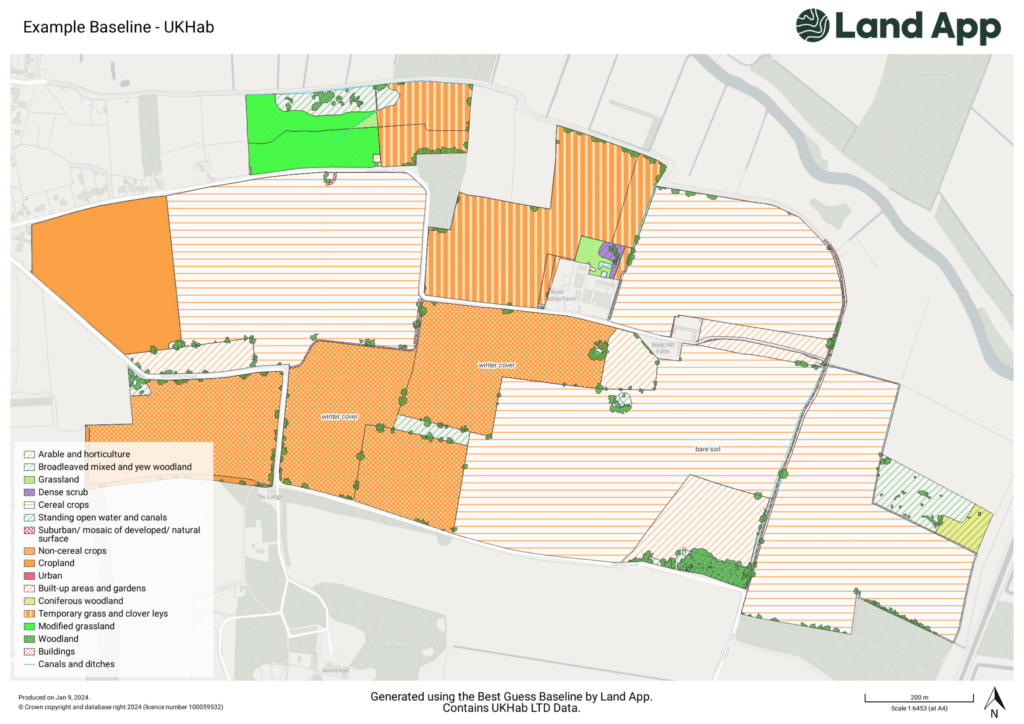
Our UK Habitat Best Guess Baseline
Alongside our partners, Land App has created an automated system for delivering a UK Habitat Best Guess Baseline using the UK Habitat Classification. This Best Guess Baseline is a single data layer that predicts which habitats make up a given area of Great Britain by combining insight from multiple third-party datasets. The result is to provide users with near-instant access to highly granular habitat data for instant insight. Any boundary file can provide a total area and location of existing woodland, grassland, urban, and cropland features can be established. This system streamlines the preparation time for site visits such as habitat assessments for Biodiversity Net Gain, or similar. Whilst we don’t recommend that this data be used as a replacement for an ecological survey, it’s a useful tool to support the accuracy, speed, and costs of them.
Learn more about our Best Guess Baseline in action here
Overall, we focus on making habitat assessments as cost-effective as possible. While there may be initial costs associated with digital mapping, the long-term benefits are clear in the accuracy and detail we help provide, and the time saved for our users. A more streamlined workflow, reduced fieldwork costs, and the ability to leverage existing digital datasets make the Land App x UKHab Ltd. partnership a stand-out innovation in speeding up habitat assessments.
