However, for this to succeed, there must be robust tools to plan, appraise, and design Biodiversity Net Gain projects efficiently and accurately, as well as provide transparent spatial data to evidence progress. That’s where Land App’s unique platform steps in.
The Land App Approach to BNG
We combine cutting-edge environmental and spatial data with an intuitive mapping platform, empowering users to seamlessly integrate biodiversity into land management and development projects. By leveraging our powerful BNG Estimator Tool and the UK Habitat Classification (UKHab) system, we can provide a clear pathway to calculating and achieving biodiversity units on your land.
Here’s why Land App stands out when it comes to BNG:
1. Instant BNG Estimation
Our BNG Estimator Tool is at the core of our BNG offering. Accessible through the platform’s Toolbox, this tool allows users to instantly calculate biodiversity units for a single map, providing a detailed breakdown for each feature on your plan. Whether you’re looking at grasslands, woodlands, or wetlands, the Estimator delivers precise unit values for your mapped habitats, streamlining the often time-consuming process of BNG planning.
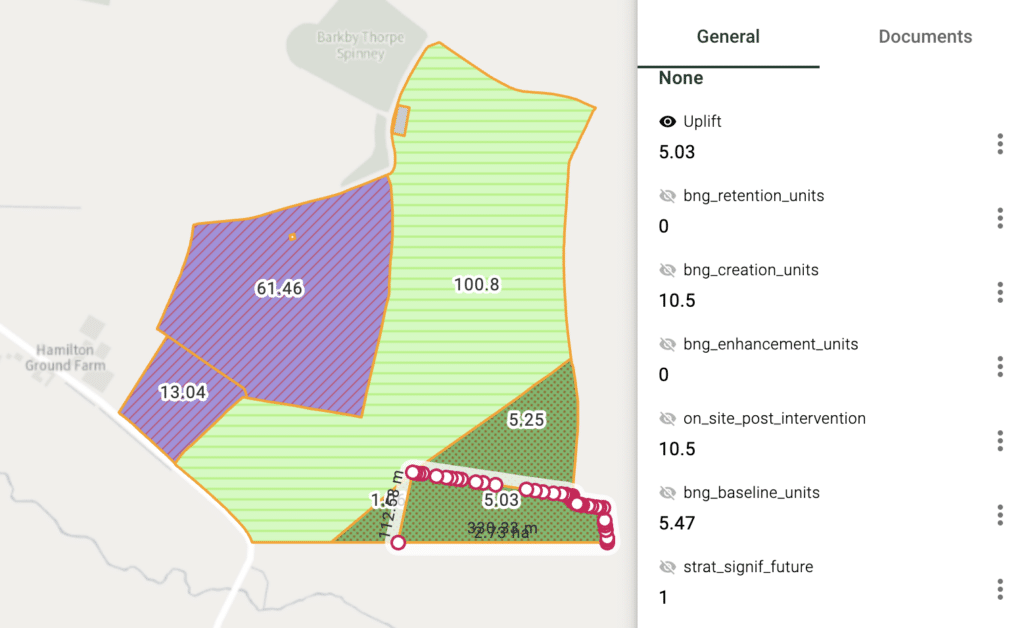
This tool allows you to work faster and smarter by giving you:
- Immediate unit calculations for any area of interest, empowering you to make informed decisions on the spot.
- Clear unit breakdowns for baseline, uplift, and creation units, helping you optimise land use for both biodiversity and financial gain.
- Scenario comparison functionality, allowing you to explore different management plans and compare outcomes easily.
2. A Simple Yet Powerful Approach to Data
One of the most crucial steps in BNG planning is ensuring that your habitat data is ready for analysis. For baseline units, Land App allows you to integrate full Baseline Habitat Assessments using Level 3+ UKHab codes, ensuring that only correctly classified habitats generate units. This precision ensures reliable and accurate BNG assessments.
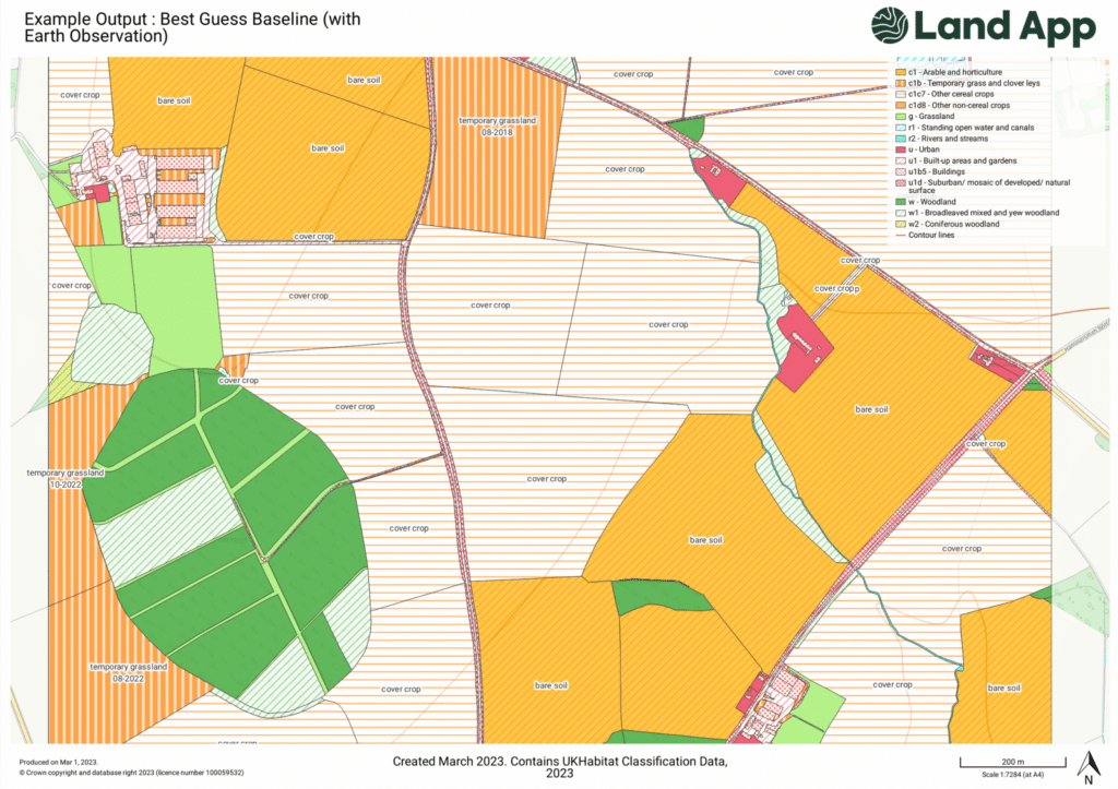
If you don’t have a baseline assessment ready, our platform offers a rapid, approximate solution: the UK Habitat Best Guess Baseline. This feature, developed in partnership with UKHab, provides a high-quality estimation of your area’s habitats using live data from trusted sources like Ordnance Survey, Natural England, and Earth Observation Data. With this tool, even users without full habitat surveys can quickly assess the BNG potential of their land. Please note this is not a substitute for a baseline conducted by an Ecologist and should be used as a guide only.
3. Maximising Biodiversity Uplift
Land App’s BNG tools don’t stop at just calculating baseline data. For those looking to enhance biodiversity, our platform offers a clear approach to measuring uplift units. By creating land management plans with UKHab codes, you can measure changes in primary habitat types (creation units) or improvements in habitat condition (enhancement units).
The flexibility of Land App allows for easy experimentation with different scenarios, giving you the power to plan for the best environmental – and financial – outcomes. You can create multiple plans and receive instant comparison scores to determine the most effective approach for achieving BNG targets.

4. A Sector- Leading Partnership for Impact
Our partnership with UKHab sets Land App apart as a trusted leader in the BNG space. As the official classification system for BNG, UKHab ensures that Land App users are working with the most reliable and up-to-date data. This collaboration enhances the delivery of better environmental outcomes by:
- Supporting habitat surveys and assessments with comprehensive training and sector consistency.
- Ensuring ongoing updates as new data and classification systems evolve, driven by feedback from our users.
- Facilitating real-world results, using accurate data to inform sustainable land use and development.
5. Unlocking Financial Potential Through Biodiversity Net Gain
One of the key advantages of using Land App is its ability to reveal the financial benefits of BNG. By integrating biodiversity into your land use strategy, you not only contribute to environmental recovery but also open up opportunities in emerging natural capital markets.
With the Land App platform in partnership with expert advice, farmers, developers, and landowners can:
- Visualise how different land management strategies affect biodiversity outcomes.
- Calculate the financial returns of achieving biodiversity uplift, whether through selling biodiversity credits or enhancing land value.
- Seamlessly integrate BNG into existing workflows, reducing time and effort while maximising impact.
The Future of BNG with Land App
As BNG continues to gain momentum across England, the need for user-friendly, powerful tools has never been greater. Land App delivers exactly that – an all-in-one platform for planning, appraising, and designing BNG projects with ease.
Our unique combination of live data, instant calculations, and a partnership with UKHab ensures you are equipped to meet the challenges of BNG head-on. Whether you’re a landowner looking to maximise the ecological and financial value of your land or a developer navigating new regulatory landscapes, Land App offers the tools and insights needed to succeed.
With our ongoing commitment to innovation, training, and data integrity, we’re proud to be at the forefront of the BNG revolution.
Interested to learn more about our offering? Get in touch with the team at sales@thelandapp.com

