Preparing for Biodiversity Net Gain: Key Considerations
February 2024 marks the long-awaited launch of Biodiversity Net Gain (BNG), marking a new opportunity for land managers.

February 2024 marks the long-awaited launch of Biodiversity Net Gain (BNG), marking a new opportunity for land managers.
January has been a fantastic start for us here at Land App, as we continue to make progress on our projects with the DEFRA departments about managing the natural capital market.
Recently, we announced our partnership with UKHab Ltd, helping to bring efficiency, consistency, and accuracy to the way habitat assessments are carried out.
Explore the latest Land App update featuring enhanced feature navigation, improved photo management, and detailed toolbox descriptions for all users. Additionally, Professional users can now access the Biodiversity Net Gain Estimator tool, revolutionising planning and land management capabilities. Free Subscription Updates Click through overlapping featuresEasily navigate overlapping features like land registry data by clicking through …
The UK Habitat Classification system (also referred to as UKHab) is a coding system used for surveying and classifying habitats when conducting a habitat assessment. By assigning specific ecological features a primary habitat code, secondary code, and condition score, it enables ecosystems to be mapped with accuracy and detail.

Biodiversity Net Gain (BNG) is a central policy for both development and conservation in England, introducing a new focus to the way we approach land development. This blog explores what BNG is: its key points, purpose, and why it matters to various stakeholders.
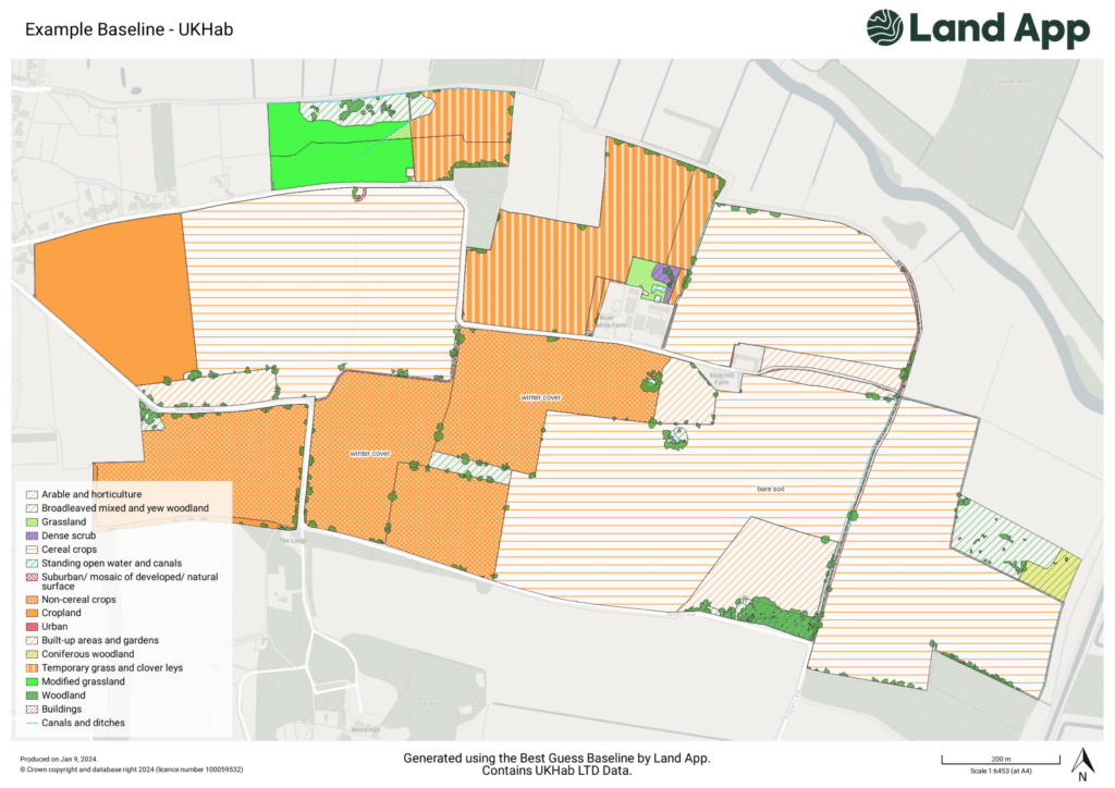
We’re pleased to share that our Professional subscribers now receive 30% off UK Habitat Best Guess Baseline data.
As the land management sector begins the transition to digital mapping in earnest, habitat mapping has become more sophisticated, and important. Habitat assessments will play an important role in new environmental land management schemes, developments for Biodiversity Net Gain, Landscape Recovery and so much more…
In this case study, Chris Cary, Senior Rural Surveyor at Woolley & Wallis details how his company has fully embraced Land App and explains how the mapping platform now acts as an integral tool to their planning and development department. Chris outlines that “we are heavily involved with rural planning, with instructions ranging from the positioning of Milk Vending Machines to the conversion of whole farmsteads into housing or commercial estates. Whatever the job, Land App proves invaluable for every application in some shape or form”.
Issues around land use, food systems, and farming have never been more pressing. As COP28 – the global climate conference – draws to a close, our Communications Lead, Tristan O’Leary, reflects on the outcomes and their impacts for land use and farming in the UK.